
Quadrkopter X-04 - multifunctional drone for special tasks


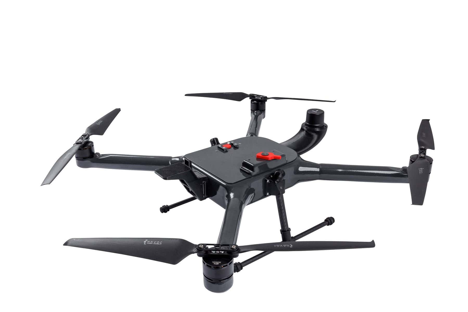

Quadrocopter X-04 - Versatile drone, rugged solution for many industries
The X-04 quadcopter is Fotoacc's latest proprietary product, designed for multi-purpose aerial operations. Thanks to its versatility and ability to integrate with a variety of components, the X-04 will work well in a wide range of applications, from monitoring and inspection, to rescue, to photogrammetric and agricultural operations. The unmanned device can be easily customized to meet specific mission needs by mounting components such as zoom, thermal, and multispectral cameras, DRONIKA environmental measurement trays, medical packages, and even spray applicators.
Advanced design
The X-04 quadcopter is distinguished by its ultralight shell construction made of durable composite materials such as carbon fiber and basalt. Such construction ensures high resistance to adverse weather conditions, impacts and other external factors. Despite its robustness, the drone maintains a small size, which makes it easy to transport to hard-to-reach areas. In addition, the unassembled design reduces the time of preparation for flight, eliminating the risk of incorrect assembly.
Performance and functionality
The X-04 quadcopter offers impressive performance. Its unloaded flight time is up to 45 minutes, and with a full load (up to 3 kg) - up to 20 minutes. The maximum speed is 12 m/s (43.2 km/h), which allows it to perform missions quickly and efficiently. The device is equipped with manual and automatic control systems, as well as advanced telemetry and visual communications via the 868 MHz, 5.8 GHz and LTE bands. The data and vision transmission range is up to 2 km, but with LTE technology the range becomes virtually unlimited, giving full operational freedom, even in the most demanding missions.
Versatile applications
The X-04 quadcopter is an ideal tool for a wide range of specialized tasks. With the ability to mount various modules and accessories, the drone can perform operations such as:
The X-04 quadcopter offers a number of optional extras, such as the ability to mount an RTK system that provides location precision of up to 10 cm. The drone can perform automatic flights with vision and data transmission without distance limitations using LTE connectivity. The device comes in a dust- and waterproof case (IP67), ensuring its safety during transportation.
Technical specifications:
We are part of Drone Space Valley Read the rest Offers.
#Quadrocopter #DroneAll-Purpose #DroneForPhotogrammetry #DroneInspection #Drones #DroneSystems #DroneMonitoring #DroneAgriculture #DroneRescue #DroneApplication #DroneCameras #DroneInspection #DroneTermaVision #DroneRTK.
The X-04 quadcopter is Fotoacc's latest proprietary product, designed for multi-purpose aerial operations. Thanks to its versatility and ability to integrate with a variety of components, the X-04 will work well in a wide range of applications, from monitoring and inspection, to rescue, to photogrammetric and agricultural operations. The unmanned device can be easily customized to meet specific mission needs by mounting components such as zoom, thermal, and multispectral cameras, DRONIKA environmental measurement trays, medical packages, and even spray applicators.
Advanced design
The X-04 quadcopter is distinguished by its ultralight shell construction made of durable composite materials such as carbon fiber and basalt. Such construction ensures high resistance to adverse weather conditions, impacts and other external factors. Despite its robustness, the drone maintains a small size, which makes it easy to transport to hard-to-reach areas. In addition, the unassembled design reduces the time of preparation for flight, eliminating the risk of incorrect assembly.
Performance and functionality
The X-04 quadcopter offers impressive performance. Its unloaded flight time is up to 45 minutes, and with a full load (up to 3 kg) - up to 20 minutes. The maximum speed is 12 m/s (43.2 km/h), which allows it to perform missions quickly and efficiently. The device is equipped with manual and automatic control systems, as well as advanced telemetry and visual communications via the 868 MHz, 5.8 GHz and LTE bands. The data and vision transmission range is up to 2 km, but with LTE technology the range becomes virtually unlimited, giving full operational freedom, even in the most demanding missions.
Versatile applications
The X-04 quadcopter is an ideal tool for a wide range of specialized tasks. With the ability to mount various modules and accessories, the drone can perform operations such as:
- Photogrammetry and terrain scanning: taking precise measurements and mapping areas, also using LIDAR technology.
- Infrastructure inspections: monitoring of power lines, chimneys, bridges and completed construction projects.
- Monitoring and rescue operations: monitoring critical infrastructure, locating missing persons, dropping rescue packages.
- Agriculture and environmental protection: spraying over agricultural and forestry crops, measuring air and water pollution.
- Transportation and delivery: fast and safe delivery of packages to hard-to-reach places.
The X-04 quadcopter offers a number of optional extras, such as the ability to mount an RTK system that provides location precision of up to 10 cm. The drone can perform automatic flights with vision and data transmission without distance limitations using LTE connectivity. The device comes in a dust- and waterproof case (IP67), ensuring its safety during transportation.
Technical specifications:
- Frame: Shell, carbon fiber
- Number of engines: 4
- Weight of the drone with battery: 4 kg
- Payload weight: Up to 3 kg
- Span between engines: 760 mm
- Operating temperature: -20°C / +35°C
- Unladen flight time: Up to 45 min
- Flight time with maximum load: Up to 20 min
- Maximum flight speed: 12 m/s (43.2 km/h)
- Communication range: Up to 2 km (up to 10 km in automatic mode without data transmission, unlimited range with LTE)
- Transportation: dustproof and waterproof case (IP67)
We are part of Drone Space Valley Read the rest Offers.
#Quadrocopter #DroneAll-Purpose #DroneForPhotogrammetry #DroneInspection #Drones #DroneSystems #DroneMonitoring #DroneAgriculture #DroneRescue #DroneApplication #DroneCameras #DroneInspection #DroneTermaVision #DroneRTK.